Scott's Point Project site exhibit map
Document
CH_CA_2021_SC_015_001
Community Archive
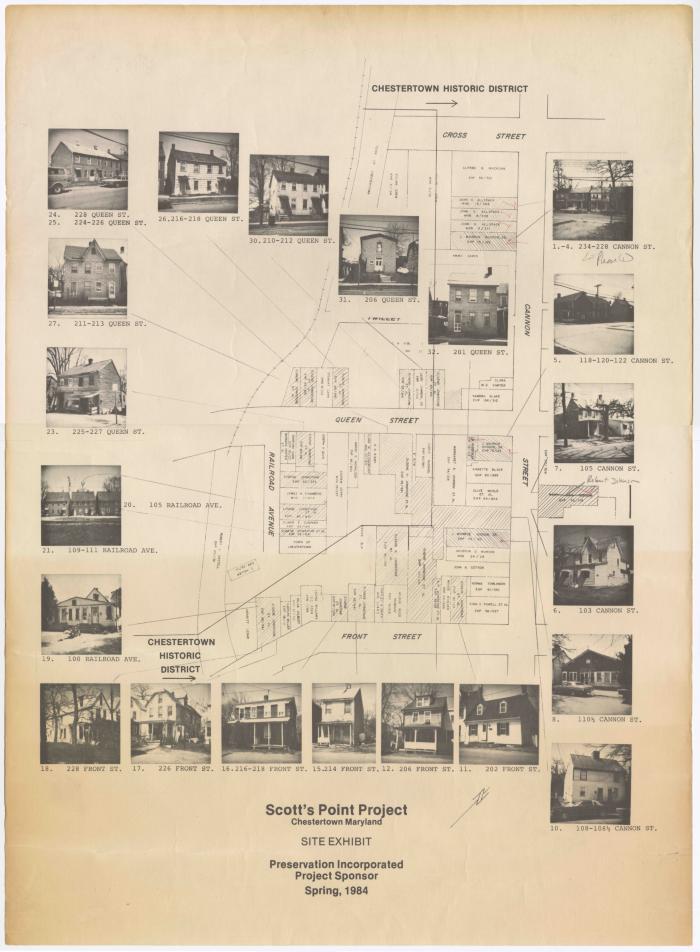
Map highlighting the locations of historic houses and buildings in the Scott's Point area of Chestertown for a preservation project. Images of some of the locations are also shown on the map. Scott's Point was the waterfront area that once home to a large free African American population in the 18th century. By the mid-twentieth century much of the property in Scott's Point was owned by African American business owner Elmer Campher. In 1988 the property was sold and gentrification of the area began. Today, only a few of the older African American homes remain on Water Street, formerly known as Front St.. Some of the prominent residents of the area were Isaac Boyer, a drayman, and Levi Rogers, a former slave. As free African Americans, Boyer and Rogers purchased homes in 1849 in Scott's Point. Boyer purchased 210 Water Street and Rogers purchased 202 Water Street, where he operated an oyster house, Cape May Saloon, from the location in the 1850s. 202 Water Street is highlighted on the map below.
Historical Society of Kent County
Kent County Public Library
Clifton M. Miller Library
Starr Center for the Study of the American Experience at Washington College
1984Kent County Public Library
Clifton M. Miller Library
Starr Center for the Study of the American Experience at Washington College
English
maps (documents)
Scott's Point
Pictorial maps, Historic preservation Chestertown
Attribution-NonCommercial-ShareAlike (CC BY-NC-SA). This license lets others remix, adapt, and build upon your work non-commercially, as long as they credit you and license their new creations under the identical terms.
© Unknown